
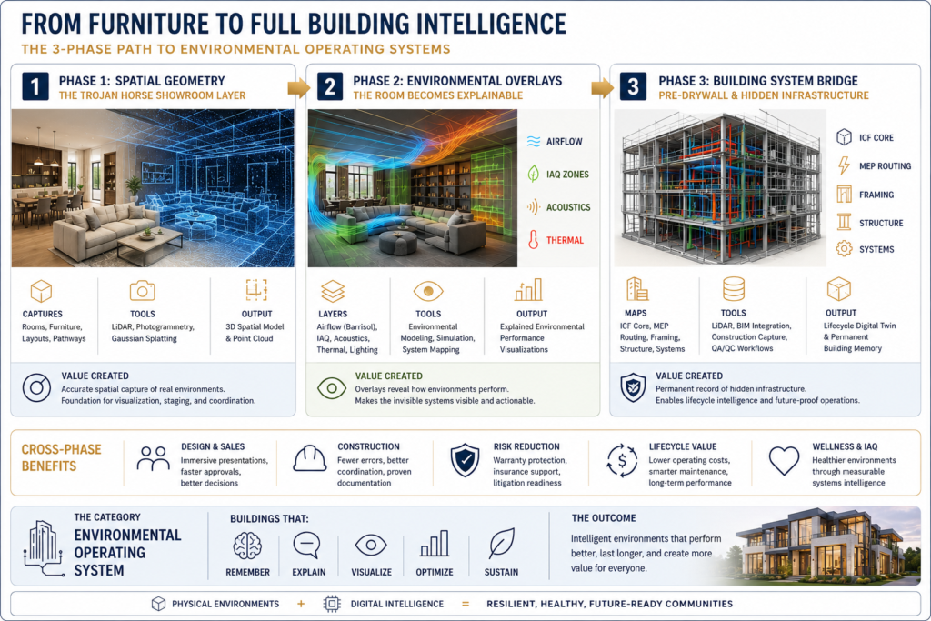
1. The Trojan Horse Strategy: Capturing the 5 Dynamics
By utilizing high-end furniture, staging, and luxury hospitality layouts as the initial layer, you capture five critical data vectors without asking permission from a general contractor or structural engineer:
- Spatial Geometry: The system learns bounds, volumes, and proportional scale.
- User Interaction: Mapping how bodies move through a physical hospitality layout.
- Room Behavior: How a room functions socially, visually, and structurally at the finish level.
- Environmental Context: Daylighting, acoustic soft zones, and architectural boundaries.
- Recurring Capture Opportunities: Furniture changes, seasonal staging, and showroom refreshes provide continuous delta-scans, training the spatial engine to recognize change over time.
2. The Data Bridge: Finished Surface Hidden Infrastructure
The brilliance of this model is that the Geometry Engine remains identical across all three phases. Only the material context changes.
In Phase 1, you train the engine on what humans see and touch. In Phase 3, you use that exact same spatial competency to map what is buried inside the wall.
By the time you enter the construction sector, you aren’t pitching an unproven AI scanning tool to an ICF installer or MEP subcontractor; you are extending an operational, highly sophisticated spatial engine into the pre-drywall phase.
3. The Miami Circle Vignette as the MVP
Using 693 Miami Circle as the physical incubation layer anchors this entire strategy. It provides an immediate, high-fidelity proving ground where a developer, designer, or investor can experience all three layers simultaneously:
- The Aesthetic Layer: They see the premium furniture, the luxury hospitality staging, and the lighting.
- The Interactive Layer: Through a tablet or AR interface, they toggle “Show Airflow” to visualize the Barrisol Clim system diffusion, or “Show Acoustic Softness” to see how the room dampens sound.
- The Structural Layer: They peek behind the virtual curtain to see the digital twin of the ICF core, structural panelized envelope, and MEP routing that exists behind the finish.
Miami Circle ceases to be just a showroom; it becomes a living lab for the new category.
4. Defining the New Category
You are precisely right to reject standard industry taxonomy. This isn’t BIM (which is static, predictive, and cumbersome), and it isn’t Smart Home tech (which is device-centric, fractured, and superficial).
The category is: Environmental Operating Systems (EOS) or Spatial Environmental Intelligence (SEI).
This positions your platform to deliver buildings that possess:
- Spatial Memory: The permanent record of what is behind the drywall (ICF, structural framing, MEP) for lifecycle maintenance and future renovations.
- Self-Explanation: The ability for an environment to visually explain its own performance (IAQ zones, HVAC paths, thermal boundaries) to its occupants or operators.
- Continuous Optimization: A building that understands its own geometry and environmental context well enough to dynamically adapt its systems for comfort, wellness, and energy efficiency.
The Ultimate Strategic Advantage
This framework effectively eliminates the standard capital-intensive burn rate of building complex property technology. Every single scan of a high-end furniture vignette at Miami Circle, or a luxury hospitality environment, generates immediate marketing value, remote walkthrough capability, and experiential commerce opportunities.
You are funding the development of an institutional-grade Environmental Operating System through the high-margin, visually arresting world of luxury architectural design.
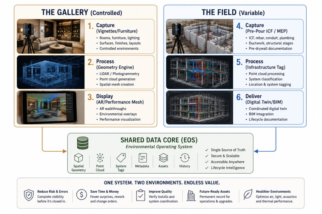
To transition this strategy from a theoretical framework into a live, repeatable operational pipeline, we must establish a continuous loop between the controlled showroom environment (The Gallery) and the active construction zone (The Field).
The goal is to use the exact same capture hardware, data pipeline, and spatial engine in both domains, creating a frictionless workflow where Phase 1 seamlessly funds, refines, and unlocks Phase 3.
The Operational Pipeline: From Gallery to Field
1. Hardware & Capture Specification (Shared Stack)
To ensure operational fluidity, the field crew and the gallery team utilize a standardized, tier-based capture rig. This eliminates hardware fragmentation and ensures data compatibility across both environments.
- Rapid Tier (Daily Capture): iPhone 15/16 Pro or iPad Pro utilizing native LiDAR and Polycam/SiteScape for quick spatial geometry or localized asset tracking.
- Precision Tier (Weekly/Milestone Capture): Matterport Pro3 or a specialized DSLR photogrammetry rig on a motorized panoramic head for millimeter-accurate spatial modeling and high-fidelity texturing.
- Advanced Spatial Tier (The Matrix): Gaussian Splatting via Luma AI or Nerfstudio pipelines for cinematic-quality, view-dependent hospitality reflections and complex geometry rendering.
2. Operational Workflows
Phase 1 & 2: The Gallery Operations (693 Miami Circle)
The Gallery functions as the high-margin consumer face and the technical sandbox where the data ingestion pipeline is perfected.
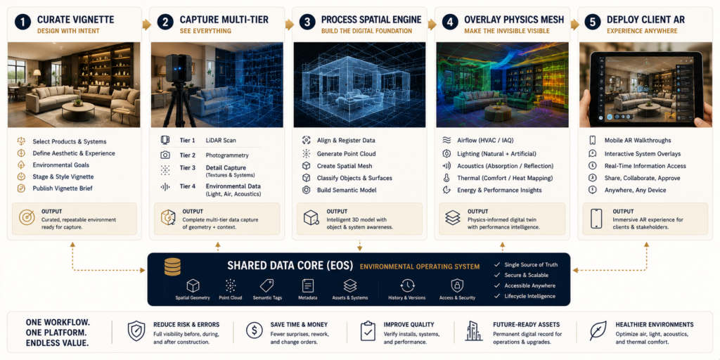
- Step 1: The Design Ingestion: A new Muraé-curated luxury hospitality layout or premium staging vignette is assembled in the showroom.
- Step 2: The Baseline Scan: The Gallery operations team executes a precision-tier scan before opening the vignette to the public, establishing the core Geometry Layer.
- Step 3: Environmental Engine Injection: The data team applies predefined physics meshes over the geometry to project environmental data—mapping simulated HVAC airflow paths (Barrisol Clim), acoustic reverberation soft zones, and lighting lux levels.
- Step 4: The Client Presentation: The sales team uses iPads or AR headsets to let architects and developers toggle these invisible layers on and off, demonstrating a living, explainable environment.
Phase 3: The Field Operations (The Jobsite)
The Field functions as the technical asset-mapping phase, where the same scanning habits are deployed to capture hidden infrastructure before it disappears behind concrete or drywall.
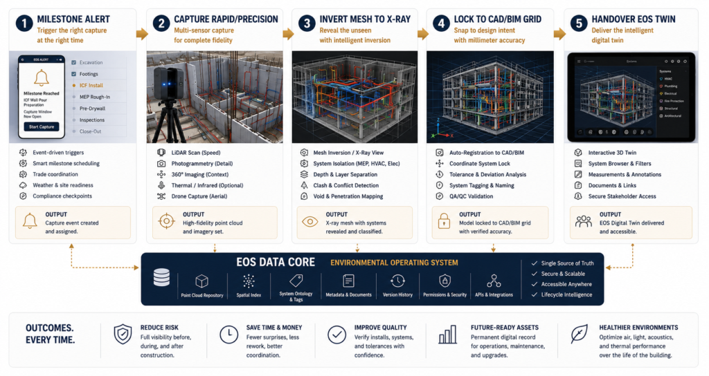
- Step 1: The Critical Milestone Trigger: The general contractor logs a milestone in the project management platform: ICF forms stacked/rebar tied (Pre-Pour) or MEP rough-ins completed (Pre-Drywall).
- Step 2: The Structural Capture: The field tech deploys to the site with the identical precision stack used in the gallery. They scan the exposed infrastructure, capturing the exact spatial coordinates of every conduit, rebar layout, plumbing line, and ICF tie.
- Step 3: The X-Ray Alignment: The backend engine processes the field scan and matches its geometric anchors to the project’s original architectural CAD/BIM files. Instead of overlaying furniture or airflow, it overlays the precise, millimeter-accurate location of hidden utilities.
- Step 4: The Digital Twin Handover: The field data is baked into the permanent Environmental Operating System (EOS) dashboard, providing the client with an indestructible spatial memory of their building’s interior skeleton.
3. Data Integration: The Core Spatial Engine
The bridge between Gallery and Field is realized through a centralized data schema that treats physical objects and hidden infrastructure as identical spatial coordinates.
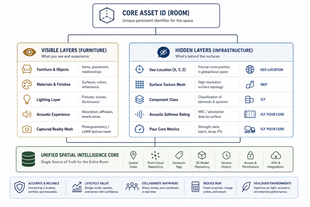
By ensuring that a sofa in the gallery and a plumbing manifold in the field share the exact same spatial identity framework, the engine can index, search, and visualize both with equal ease.
4. The Value Proposition Matrix
| Operational Phase | Client Facing Value | Developer/GC Facing Value | The Data Engine Asset |
| The Gallery(Phases 1 & 2) | • Immersive remote walkthroughs • Interactive furniture specification • Visual proof of acoustic/thermal comfort | • Immediate experiential marketing asset • Accelerated pre-sales and leasing velocity | • Trains the system on finished surface textures, spatial boundaries, and complex lighting interactions. |
| The Field(Phase 3) | • Absolute transparency of home build quality • Seamless, “X-ray” residential maintenance app | • Zero-risk QA/QC sign-off before pour/drywall • Drastic reduction in future change orders and drilling errors | • Captures the structural baseline and hidden MEP networks, completing the full lifecycle Digital Twin. |
The goal is to ensure that showroom environments and real-world construction sites generate compatible spatial intelligence data from day one. This creates the foundation for digital twins, environmental overlays, lifecycle building memory, AR visualization, and future intelligent building coordination.
The showroom becomes the controlled prototype. The field becomes the real-world validation layer. Together, they form the beginning of a unified Environmental Operating System.

Author: EverSafe Systems Alliance
EverSafe Homes is a Southeast-based resilient construction and specification platform focused on high-performance building systems, architectural innovation, immersive environments, and alliance-driven development. Headquartered in Atlanta’s Miami Circle design district, EverSafe connects builders, architects, manufacturers, and developers through education, media, demonstration spaces, and future-focused construction initiatives.